The geophone array gets laid out along K Street NW before sunrise. We run the cables across cracked sidewalks from Dupont Circle to Foggy Bottom, avoiding early commuters. A 12-pound sledge hits the aluminum plate. The shot gathers come back clean on the seismograph. In Washington DC, seismic microzonation is not about massive subduction zones. It is about basin effects. The soft sediments of the Atlantic Coastal Plain trap energy and amplify shaking at specific frequencies, even from distant events like the Mineral, Virginia earthquake. We measure shear-wave velocity profiles to 30 meters depth, classify the site per ASCE 7 Chapter 20, and map where ground motions will ring harder. The city sits at 38.9°N on Cretaceous sands and silts of the Potomac Group. That geology demands site-specific hazard analysis, not generic code assumptions. We often integrate this with MASW surveys to resolve stratigraphic contrasts across the Fall Line and seismic refraction where bedrock depth varies abruptly near Rock Creek Park.
In DC, the same magnitude 5.8 event shakes Foggy Bottom differently from Anacostia. Site period governs structural response, not distance to the epicenter.
Technical details of the service in Washington DC
Risks and considerations in Washington DC
We see the same mistake on design-build projects across the District. The structural engineer defaults to Site Class D without checking the boring log. Then the geotech runs a single downhole test in one corner of the lot. Two years later, a facade inspection reveals diagonal cracking at the reentrant corner. The culprit is differential amplification. The east half of the building sits on 25 feet of soft Potomac Group clay. The west half bears on terrace gravel at 8 feet depth. The fundamental periods differ by a factor of three. During the 2011 Virginia earthquake, that difference would have twisted the diaphragm. A proper seismic microzonation survey would have caught it. We grid the site at 50-meter spacing, map Vs30 variability, and deliver site-specific response spectra per ASCE 7 Section 21. No generic coefficients. No assumptions. Just measured data tied to the actual stratigraphy beneath the foundation footprint.
Our services
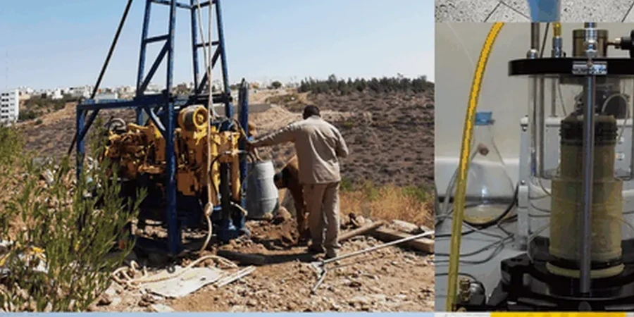
Our seismic microzonation work in Washington DC covers the full workflow from field acquisition to response spectra, adapted to the District's unique geology and regulatory environment.
Vs30 Site Classification Mapping
Grid-based MASW and downhole seismic surveys to assign Site Class A through F per ASCE 7 Chapter 20, covering entire blocks or campus-scale developments.
Site-Specific Response Spectra
One-dimensional equivalent linear and nonlinear site response analysis using DEEPSOIL or SHAKE, integrating USGS hazard curves with measured Vs profiles and modulus reduction curves.
Liquefaction Microzonation
Assessment of liquefaction potential index (LPI) across sites with shallow groundwater and loose granular soils, common in fill zones along the Anacostia waterfront.
Seismic Hazard Reports for DCRA Submission
Complete geoseismic reports meeting DC Department of Buildings review requirements, including ground motion parameters, seismic design category, and foundation recommendations.
Quick answers
Does Washington DC actually need seismic microzonation given its low seismicity?
Yes. The District sits on unconsolidated Atlantic Coastal Plain sediments that amplify long-period ground motion. The 2011 Mineral earthquake damaged the National Cathedral and Washington Monument despite an epicenter 85 miles away. Site effects control damage patterns here, not proximity to faults.
What is the typical cost of a seismic microzonation study for a DC site?
For a standard city lot or small development in Washington DC, expect a range from US$3,990 for a basic MASW survey with Vs30 mapping to around US$14,330 for a full microzonation including downhole testing, site response modeling, and a DCRA-ready report.
How does the Fall Line affect seismic hazard in DC?
The Fall Line runs diagonally through the city, separating hard Piedmont bedrock to the northwest from deep Coastal Plain sediments to the southeast. West of Rock Creek, sites often classify as C or B. East of the Anacostia, deep soil sites reach class E or F. This boundary creates sharp contrasts in ground motion amplification over short distances.
What methods do you use to measure Vs30 on constrained urban sites?
We rely heavily on MASW and ReMi arrays because they need no drilling. We set geophones along sidewalks, parking lots, or closed traffic lanes. Where space is extremely limited, we use downhole seismic in a single boring, with a triaxial geophone clamped at 1-meter intervals.
What deliverables do DC building officials require for seismic design?
The DC Department of Buildings typically requires a geotechnical report with site class determination per ASCE 7, mapped spectral accelerations Ss and S1, site coefficients Fa and Fv, and the design response spectrum. For taller structures or essential facilities, site-specific ground motion analysis following ASCE 7 Chapter 21 is mandatory.