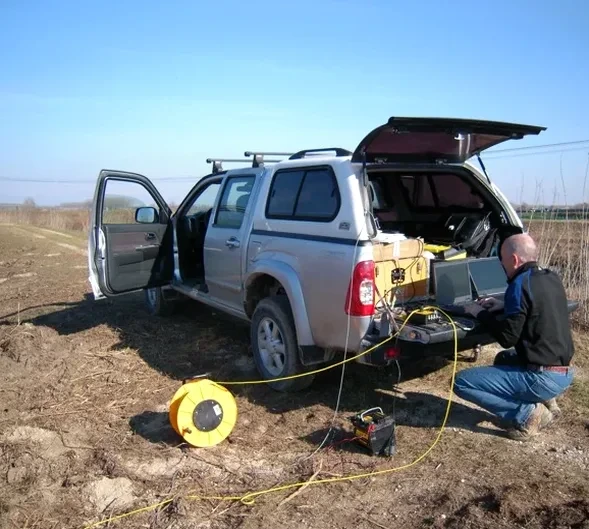
A geophone line stretches across the lot, cables running to a 24-channel seismograph housed in a rugged yellow Pelican case. In Washington DC, where the Coastal Plain sediments meet Piedmont crystalline rock just west of Rock Creek Park, the sledgehammer source sends P-waves downward. The refraction tomography survey maps the critical transition from artificial fill and Potomac Group sands into weathered and competent bedrock. We deploy 48-channel arrays when the target exceeds 100 feet deep. The city's variable geology—from soft alluvium near the Anacostia River to hard schist and gneiss under Dupont Circle—demands acquisition parameters tuned block by block. Combining this with a CPT test gives you a continuous soil behavior type profile, while the MASW method adds shear-wave velocity for site class determination per IBC Chapter 16.
Seismic velocity is a direct physical measurement, not a correlation. In DC's Fall Zone, that distinction saves projects from foundation redesign.
Technical details of the service in Washington DC
Risks and considerations in Washington DC
The mistake we see repeatedly in Washington DC is relying solely on sparse borings in areas of known paleochannel complexity. The Potomac River’s ancestral terraces left buried channels filled with soft organic silts and loose sands that a 50-foot boring grid easily misses. A developer near Buzzard Point did exactly that—and hit a 20-foot-thick pocket of compressible material under what refraction would have shown as a distinct low-velocity trough. The result: a six-month delay, redesign of the mat foundation, and unplanned ground improvement. The IBC requires site class determination, and ASCE 7-22 ties design spectra directly to Vs30. Guessing the velocity profile from blow counts introduces error. Tomography provides measured values. When the site lies within the Fall Zone—where rock depth can change 40 feet across a single lot—skipping seismic investigation is a schedule and budget risk that no experienced local contractor accepts anymore.
Our services
Our seismic tomography services in Washington DC combine high-resolution field acquisition with advanced processing to deliver actionable subsurface models for foundation design, excavation planning, and seismic site classification.
Refraction Microtremor (ReMi) & Active MASW
We collect surface wave data using the same geophone spreads to produce 1D and 2D Vs profiles, ideal for Vs30 calculation and IBC site class determination in urban DC lots where space limits the array length.
Borehole Seismic Tomography (Crosshole & Downhole)
When high-resolution interval velocities are required between existing borings, we run crosshole surveys with a sparker source and hydrophone chain, delivering P-wave and S-wave velocity logs at 0.5-foot spacing.
Quick answers
How long does a seismic refraction survey take on a typical DC lot?
A standard 2-line refraction survey on a quarter-acre site with a 48-channel spread takes one field day. Processing and reporting—including tomographic inversion, Vs30 calculation, and a written report with interpreted cross-sections—requires 3 to 5 business days. Sites with limited access or nighttime noise restrictions near Metro lines may add a day.
Can seismic tomography work on paved or concrete-covered sites in the city?
Yes. We couple geophones to asphalt or concrete using plaster or mounting putty; the sledgehammer or weight-drop source generates sufficient energy. However, if the pavement is heavily reinforced and slab thickness exceeds 8 inches, high-frequency noise can reduce data quality. In those cases we recommend coring small access holes for geophone placement or switching to a borehole-based method.
What does a seismic refraction/reflection survey cost in Washington DC?
For a standard 2D refraction line with 48 channels and a sledgehammer source, the cost ranges from US$3,110 to US$5,900 depending on line length, depth of investigation, and site constraints like traffic control or noise restrictions. Reflection surveys using an accelerated weight drop and longer spreads fall at the upper end due to additional equipment and crew time. A firm quote follows a site walk and review of the exploration objectives.